Posts

Showing posts with the label Zion National Park

Glorious Utah, Kolob Canyon

Image
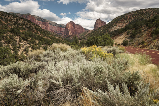
Coming away from Zion Canyon and heading back towards Las Vegas, Mike took a planned diversion up the Kolob Canyon Road. This is still part of Zion National Park, but it has less visitors, and has some remarkable views over the mountains. The single road ends at a parking area for the Kolob Canyon Viewpoint and Timber Creek Overlook Trail. It is lined with severe cliffs of Navajo sandstone, up to 600m high. Everything seems red, even the road surface. The sage brush was in flower, giving lovely yellow accents. Left is Beatty Point, with the little nipple on the top, centre is Nagunt Mesa, to the right is Timber Top Mountain(8055') The mountains are higher than they look. This part of Zion has the highest peak in the Park, Horse  Ranch Mountain, at 2660m.  The Timber Creek Overlook Trail is only 1/2 mile long and ends in a scramble of rocks. But it is well worth doing for the panorama of mountains that you can see. The views e

Glorious Utah, Canyon Overlook Trail

Image
This last day around Zion was very busy as we tried to pack more stuff in before returning to Las Vegas in the late afternoon. We got into Zion Canyon early to do a trail which starts on the Zion-Mount Carmel Road, so it is not necessary to park up and take the shuttle bus to reach it. Canyon Overlook Trail was my favourite walk in Zion. It had not yet got too hot and there was plenty of shade. The path was quite precipitous but safe with railings on the more exposed parts. After a short steep section you can look down on the Pine Creek Slot Canyon before you pass through a cool cave. At the end of the trail there are views looking down the Mount Carmel Highway, which looked superb in the morning light. You can see the conical white form of Bridge Mountain on the left and the flat topped West Temple in the distance in these photos Here are the pictures, including one of  my nephew Mike, the ideal travel companion.

Glorious Utah, the ghosts of Grafton

Image
On the way back to where we were staying in Hurricane, we diverted off the main road to see the ghost town of Grafton. The town was first established in 1859 when Brigham Young ordered a number of Mormons to build a site for growing cotton by the Virgin River. This town of Wheeler only lasted until 1862 when it was flooded, relocated 1 mile upstream and renamed Grafton. The cotton production never really thrived as the settlers realised they needed all the land to grow food. By 1864, 168 people lived in the town. But in 1866 raiding attacks by Navajos during the Black Hawk War, forced the families to relocate to Rockville, as they were so isolated. They returned in 1868 but life was hard and the Virgin River proved a fickle servant, frequently flooding. In 1886 the schoolhouse was built, this was also used as a church and community centre. An irrigation canal was built in Hurricane in 1906. This irrigated a 20mile patch and many families left Grafton to take advantage of an easi