Posts

Showing posts with the label hoodoos

Glorious Utah, under the rim in Bryce

Image
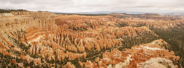
One of the most popular walks in Bryce is the Navajo Loop Trail which starts at Sunset Point, goes down from the rim on to the valley floor and meanders round the hoodoos before coming up to Sunrise Point. In September, a little off season, it was not too busy so Mike and I gave it a go. Here are some of the pictures from this journey, apologies for the high number. You can see how impressive the rock formations are when you are in amongst them. When the sun was out everything seemed to glow red. The eponymous Ebenezer Bryce who homesteaded here in the 1870's said that 'it's a helluva place to lose a cow'. Mike in Bryce Mule deer crossing the scree

Glorious Utah, spectacular Bryce Point

Image
Not being quite methodical we left out the next stop on our trip up Bryce Canyon and went straight to Bryce Point, an enormous amphitheatre of pinnacles. Here is a panorama to show the size of the place. The individual hoodoos can reach up to 200ft to give you an idea of scale. Needless say we were mightily impressed. After lunch we went on a guided geology tour where we learnt more about the rock formation at Bryce. The Canyon stands at the edge of the Paunsaugant Plateau on the northern edge of the Grand Staircase, a huge collection of steps in the landscape of the Colorado Plateau leading down to the Grand Canyon. The rock at Bryce is known as the Claron Formation, a collection of  limestone, silts and mudstone, sometimes topped with a layer of dolomitic limestone which is much harder than normal limestone and resilient to acid rain. The plateau edge is being continually eroded, mainly by frost damage but also by water flow off the edge of the canyon and is receding at a rate