Posts

Showing posts from May, 2013

29th April - Tiwanaku, a Pre Incan Archaeological Site

Image
We set off on a trip to Tiwanaku, an ancient site that is around 45 miles out of La Paz near the south eastern shore of Lake Titicaca. To get there the mini van had to drive through El Alto a large settlement which is now part of the La Paz municipality. It  has grown up on the hills around the airport, overlooking La Paz. El Alto is occupied by Aymara people who have come in from the countryside in order to find work and  has the largest population of native Americans anywhere in the world. In La Paz the best housing is in the valley around the city, poorer people build higher up where the ground is less stable. As this is Bolivia the area is subject to strikes and road blocks as people protest about their conditions. I will start with a few pictures taken driving through El Alto. As we drove in to the countryside the land became very flat, dusty and monotonous, although we could still see the mountains in the background. In truth, once we ha...

A Walk in the Winkworth Arboretum

Image
I felt I had to post something from a more recent outing than South America. On Bank Holiday Monday we went to visit my son Hugh and his girl friend in Surrey. They had very kindly organised a picnic excursion to the Winkworth Arboretum, a piece of land owned by the National Trust. Surrey has an amazing number of National Trust houses and gardens. There was a lake, rhododendrons  and bluebell woods as well as the meadow where we ate. Here are a few of the "pictures what I took". The lake had some ducklings on it who were all clustered on a tree stump. Finally some more general views of our picnic spot Hugh and Lizzie in the boat house

Sunday 28th April - Cycling El Camino del Muerte

Image
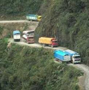
El Camino del Muerte is a 61 km road which links La Paz to the Yungas and the Amazon. It ascends the cold Cumbre Pass at 4,650m and then descends to the sub tropical town of Coroico at 1,200m. It was given its terrifying name, the Death Road, by the Inter-American Development Bank in 1995. In its heyday around 200-300 motorists a year died as a result of veering over the edge of this narrow, no part is wider than 3.2m the width of a single carriageway, and precipitous road. It is not paved, subject to being turned in to a mud bath in the summer rain and in to a dust bowl in the dry season. The height of the road and the surrounding forest means that there is often fog and mist hampering visibility. There are no guardrails and the edge is crumbly with frequent landslides. It is the only road in Bolivia where it is mandatory to drive on the left meaning that the driver coming downhill can look down to see the edge of the road on the drop side, to make passing easier! At one ti...